Six factors of pedogenesis
PDF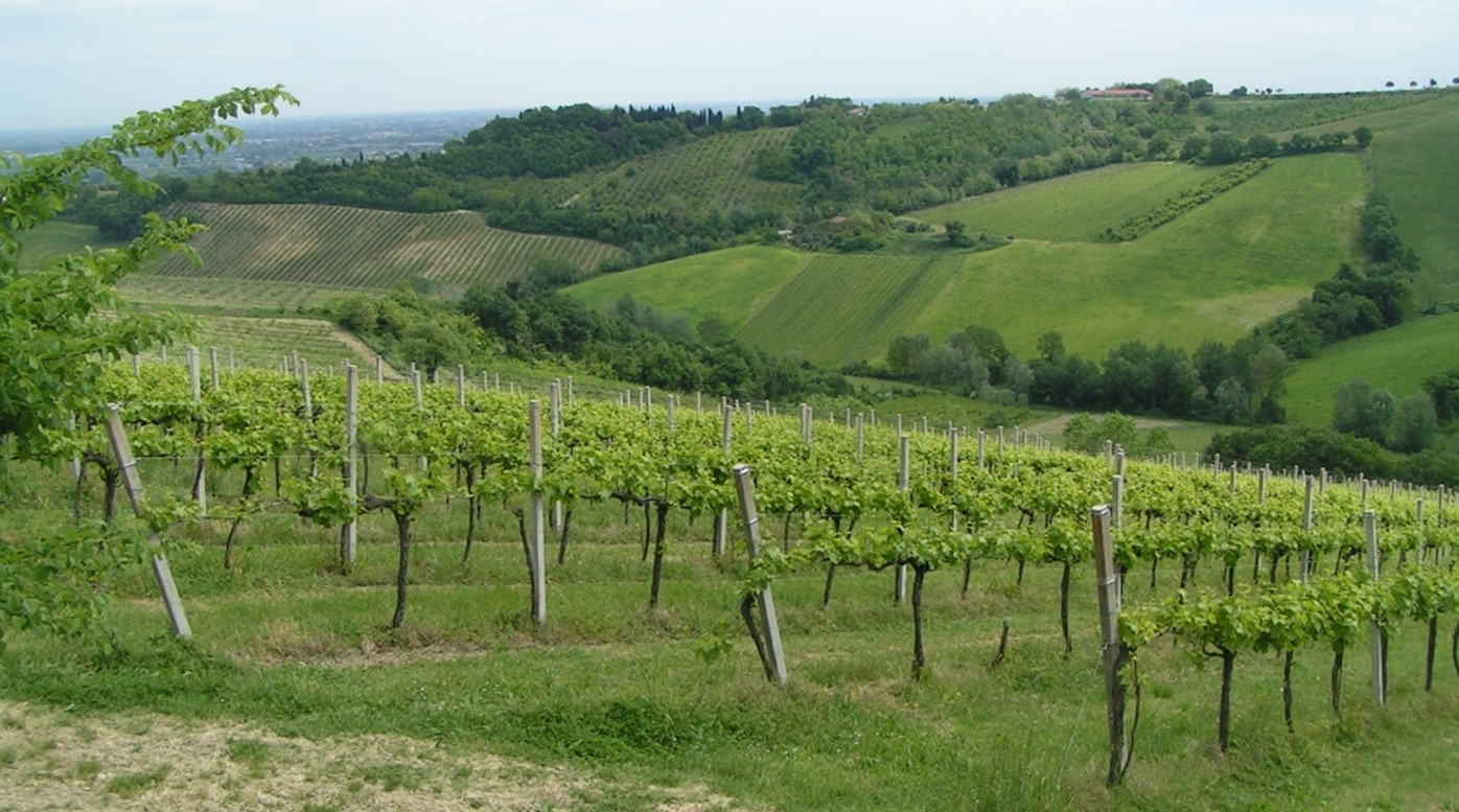
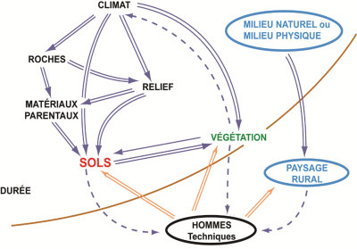
The formation of soils is the consequence of weathering of various geological materials (the “parent materials” formerly called “mother rocks”) particularly under the action of precipitation and living beings, over a long period of time. This article details the six factors that determine their formation, appearance, properties, and functioning. In our climates, the main factor is the lithology of the parent material, which initially determines the morphology and main properties of soils for a long time. But other factors play a role: the local climate, the position within the terrain, the spontaneous vegetation, not to mention the time factor. In France, many soils are relatively “young” (10,000 to 15,000 years old) but others correspond to weathering that have lasted for several million years. Since the Neolithic period and the development of agriculture, humans have also become important agents of pedogenesis. Ploughing, drainage, irrigation, fertiliser and pesticide application, liming, etc. are all interventions that profoundly modify the hydric, physical and biological functioning of soils.
1. Pedogenesis: the result of multiple interactions
A first article (See Soil formation in temperate climates) defined what soils are and their main specificities, in particular their organization into aggregates and the presence of a multiform porosity favourable to the activity of living beings.
Beware of the word “humus”, an ambiguous term with various meanings. The Comifer (French Committee for the Study and Development of Reasoned Fertilization) has given this definition: “all the organic constituents of the soil that no longer have a biological organization (plant, animal, bacterial, etc.) identifiable and which are the result of the slow biochemical evolution of the various organic matter in soils.” For this restricted meaning, scientists now prefer the formula “soil organic matter” (SOM).
Beware of the other meanings of this word:
- In common parlance, humus is the “blackish earth formed by the decomposition of plants” (from the french dictionary “Petit Robert”);
- In soil science, it was mistakenly used to refer to all surface horizons that are entirely organic and organomineral and contain a lot of organic matter. From now on, the term “humus-bearing episoleum” will be preferred.
2. Nature and state of parent materials
Parent materials are the geological formations, little or not altered, actually observed under the soil, at the bottom of a pedological pit. (See Soil formation in temperate climates)
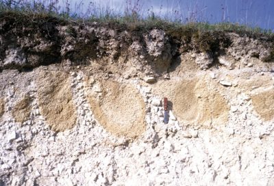
But the parent materials are also all kinds of superficial deposits that are very often the real materials in which the soils have developed:
- Alluvium (stony or fine) and colluvium (fine);
- Loess and deposits that resemble them (calcareous formations redistributed by the wind during the Quaternary), silty deposits covering the terraces of the Garonne or the Pyrenean rivers;
- Glacial moraines;
- Coarse slope formations (scree, “grèzes“, “graveluche“), but also fine slope formations or formations with significant fine components (geliflucted formations with boulders, clay-stony slope formations);
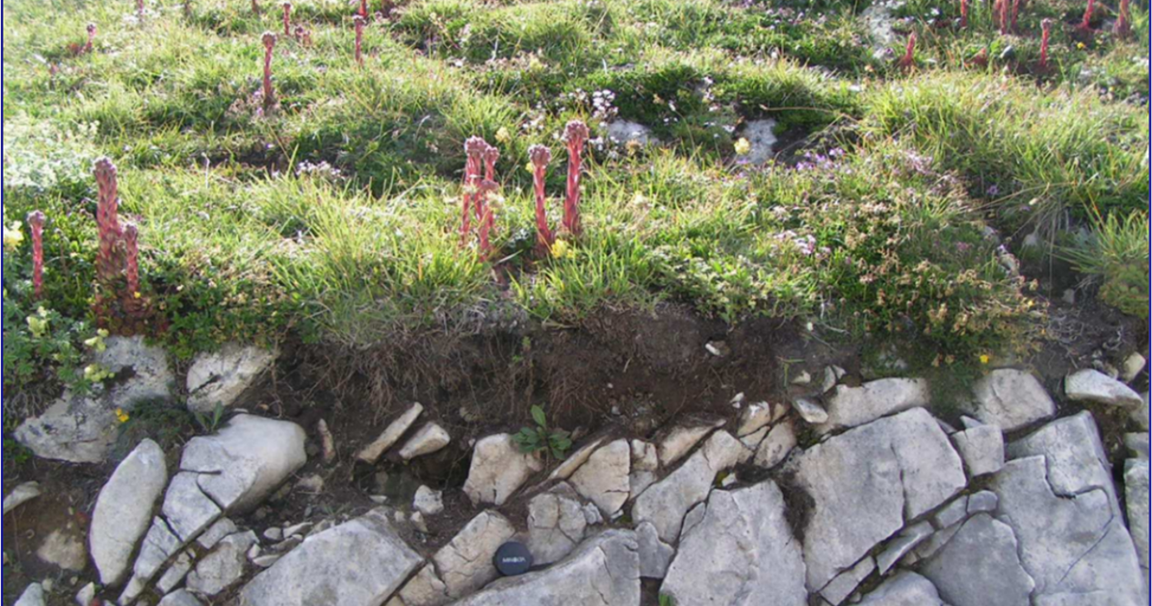
- Paleosols and cryoturbated paleosols (Figure 2);
- Residual clays issued from the decarbonatation of hard limestone (clay with cherts, “Terres d’Aubues” of Lower Burgundy (Figure 3), “silty materials in Auxois”) or soft calcareous rocks (clay with flints).
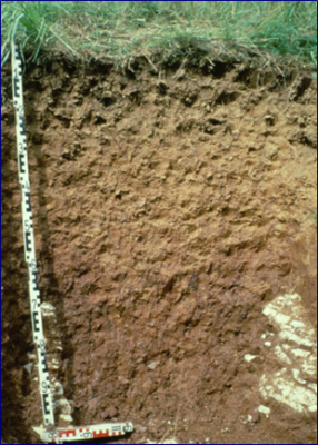
Figure 3. “Terre d’Aubue” of Lower Burgundy. Non-calcareous soil, moderately thick (1 m), silty-clayey in the uppermost horizons, clayey at depth, developed in a clay resulting from the carbonate dissolution of a hard limestone (Yonne). [Source: © Denis Baize]
Many of these formations are deliberately neglected or poorly marked by geological maps (especially the older ones, which show only an “écorché” and focus on intact rocks located deeper).
In the temperate climates of Western Europe, the parent material determines most of the properties of the future soil very strictly. For a long time, the influence of climate and vegetation remain limited. Important characteristics of the parent material, which will influence the composition and structure of the soil, are:
- its grain size (pebbles, heavy clay, sandy sediment, aeolian silt);
- the particle size of the decarbonatation residue in the case of calcareous parent materials;
- the more or less alterable nature of primary minerals (e.g. quartz is unalterable while black mica, biotite, is rapidly alterable);
- the mineralogical nature of inherited or newly formed clay minerals (kaolinite, illite, smectites, etc.);
- the petrographic nature of the parent material and the resulting physico-chemical characteristics. For example, chalky soils inherit an extremely limy composition that lasts for a very long time;
- its fine geochemistry: for example, soils developed from “green rocks” (peridotites, serpentinites), which are very rich in chromium and nickel, are themselves very rich in these two metals.
When it comes to the role of the state of an underlying material, we will take the example of hard limestones. It is clear that the different states of dislocation of the same hard rock (Figure 4) have a major influence on the rooting capacities of perennial plants [1] such as forest trees or vines. The same goes for annuals (wheat, rapeseed) which can find a little (or a lot) of interstitial earth between the stones, which can provide some water during dry periods. Thus, vegetation will be able to settle more easily in a stony formation than on undislocated rock, and the soil will form more quickly.

3. Microclimate and pedoclimate
The general climate (major climatic zones of the globe) is more or less modified by the local conditions in which each soil is located (relief, topographical position, aspect): this is the microclimate. The latter is modified by certain intrinsic properties of the soil itself (e.g. its surface colour, the presence of impermeable layers generating long-term waterlogging). In this way, the internal climate of the soil or pedoclimate can be defined.
The pedoclimatic conditions of the distant past have governed the oldest pedogenetic processes. They are generally very different from the current conditions that govern the present functioning of soils. As a result, some soils today have red hues that correspond to much warmer and drier climates than the current one.
3.1 Rainfall
Potentially percolating flow (likely to percolate vertically) is defined as the input flux (precipitation) minus the evapotranspired flux (direct evaporation from soil + transpiration from vegetation). In temperate climates, the potentially percolating flow is positive because precipitation is much higher than evapotranspiration. The greater these water flows, the greater the transfer of materials (solutions, clay particles), either vertical or lateral. (see Plants water needs).
The potentially percolating flow is more or less modified depending on the topographic position. For example, lower slopes are likely to receive runoff from higher elevations.
Snow plays a special role:
- it causes a delay in the flow (the precipitation will flow well after it has fallen) and it causes the soil to become waterlogged when it melts;
- It is an insulating coat that protects the ground from frost as long as it has fallen before the temperature drops.
3.2 Mean annual temperature and seasonal temperatures
The higher the temperature, the faster the chemical and biochemical reactions (alteration of primary minerals, biological activity, mineralization of organic matter); on the other hand, cold water is the best dissolver of limescale because, all other things being equal, cold water dissolves more CO2 than warm water. (see Karst, a renewable water resource in limestone rocks).
Conversely, prolonged or permanent freezing has mechanical effects (disintegration, cryoturbation) but slows down or stops all biological activity and weathering.
4. Position in the landscape
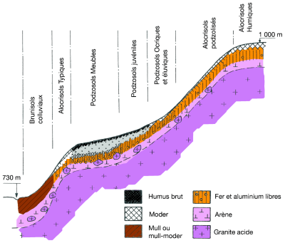
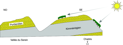
TThe functioning of the soil (therefore its general evolution in the long term) depends on its position in the relief. This is the case, in particular, with the vertical or lateral orientation of the flows of water and displaced materials. The shape of the slopes depends on the more or less hard nature and the succession of the underlying rocks. As a result, different soils follow one another on these slopes [2] depending solely on their position (soil toposequence or soil chain – Figure 5) or also on the variation of the rocks (soil topolithosequence).
4.1 Flatbed positions (plateaus)
On the plateaus, the dynamics of the water and transfers are rather vertical. So there is little or no erosion. However, there are few plateaus that do not have any relief at all, and there is no need for much slope for runoff and erosion to develop.
This is what happens when the surface horizons have very fragile aggregates as a result of a silty grain size and a low organic matter content. The sealing of the soil surface can occur under the impact of raindrops. A thin, finely bedded crust (0.5 to 5 mm) is formed, more or less continuous. This slaking crust prevents water from seeping into the soil. This results in puddles and, often, surface runoff into the plot, the initial stage of water erosion. This is the case, for example, of the plateaus of the Petit Morin catchment area in Seine-et-Marne or those of the Pays de Caux.
4.2 Upslope and mid-slopes
Upslope, there is loss of water and dissolved or suspended matters without compensation. Generally the soils are rather dry and thin (because they are more or less eroded). In the middle of the slopes, the losses of water and dissolved matters downwards are compensated by inputs from above, resulting in a neutral balance.
The south-facing slopes are hot and drier (the vegetation is rather thermophilic, even xerophilic). The north-facing slopes are rather cold. (see How do plants cope with alpine stress?).
4.3 Downslope and valley bottoms
Downslope and in the valley bottoms, water flows are much higher than precipitation, which generates more or less prolonged or even permanent or almost permanent waterlogging (peat bogs). There are also accumulations of displaced solids (colluvium) and the formation or presence of specific parent materials (fluvial alluvium, lacustrine alluvium). In these situations, thick or even over-thickened (colluvial) soils are generally observed.
The lower part of the slopes and the bottoms of the valleys correspond to areas of accumulations of dissolved products higher upslope which precipitate (iron and manganese oxides, calcium bicarbonate in the form of lime) or bind to the adsorbing complex (calcium-saturated soils – the case of the brunisols in Figure 5).
5. Vegetation and biological activity (broadly defined)
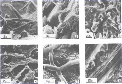
The alteration of the parent material also takes place under the action of the roots. Indeed, in the rhizosphere (volume of soil directly under the influence of exudates and associated bacteria and ectomycorrhizae), organic acids and CO2 released are likely to alter certain minerals and dissolve lime.
The fauna (micro, meso and macrofauna) is also adapted to the nature of the soil. (see Soil biodiversity).
It also plays a major role in soil formation:
- by breaking down plant debris into small molecules;
- by the absorption of nutrients (P, K, Ca, Mg), or potentially polluting trace elements at the root level;
- by the formation of aggregates with a crumb structure of certain humus-bearing surface horizons by the reorganization of earthworm castings.
In turn, the soil has an important influence on the living beings it hosts. In particular, spontaneous natural vegetation is closely dependent on certain properties of this soil: acidity, waterlogging, relative dryness, richness in exchangeable calcium, nitrogen, and fine “active” calcium carbonate. This is why, depending on the nature of the soil, plant species and associations known as acidiphilous, hygrophilous, xerophilous, calcicolous, nitrophilic, calcaricole or calcarotolerant are observed.
The above-ground parts of plants that fall to the soil surface can be “acidifying” or nitrogen-rich (so-called “improving”). After a long period of time (centuries, millennia) a balance is created between the soil, the spontaneous vegetation and the climate.
The natural biogeochemical cycle (soils-plants-soils)
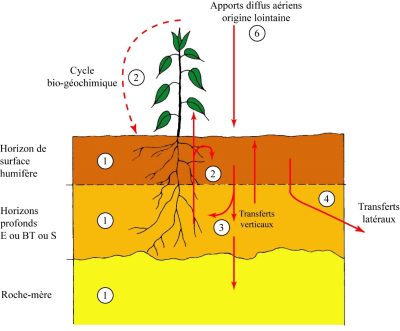
Once absorbed by the plants, these elements are transferred to their various organs (stems, leaves, fruits, seeds, branches, trunks).
After the death of the plant, these elements finally return to the soil either directly into the soil (in situ decomposition of dead roots) or by falling to its surface (debris from above-ground parts, forest litter). It is there that fresh organic matter will be decomposed more or less quickly by biological activity (microarthropods, nematodes, springtails, earthworms, fungal filaments, algae, bacteria) until, in the most “active” forms of humus, complete mineralization and therefore the release of chemical elements in fairly mobile and more easily bioavailable forms.
This results in a cycle of matter from soil to soil through vegetation. However, it should be noted that the majority of the elements absorbed over the entire thickness of soil prospected by the roots fall to the surface. This, together with the good ventilation that prevails, explains why the most intense biological activity can be observed in the first few centimetres. In a natural environment, even if it is chemically poor (Amazon rainforest, temperate forests on acidic soils), the biogeochemical cycle is sufficient to keep the ecosystem in equilibrium.
What happens when the cycle is broken, for example when humans take some or all of the plants (ears of wheat, lettuce, carrots, potatoes, fodder, tree trunks), whether they are cultivated or not, and take them elsewhere? A more or less important part of the biomass is “exported” with the elements it contains. Very generally, food products (flour, vegetables, fruit), wood and their waste (wheat husks, peelings, human or animal excrement, sawdust, ashes from fireplaces) are not returned to the place where they were taken. This results in a gradual impoverishment of the environment as the harvests progress. “Poor” ecosystems are quickly thrown out of balance and wither. Under intensive agriculture, where exports are massive, it is therefore essential to bring back to the soil all the elements (N, P, K, Ca, trace elements, organic matter) that have been removed from them, which is the reason for the addition of fertilizers and amendments (organic, calcareous). (See How to feed plants while polluting less?).
6. Human activities
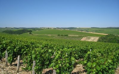
- Action on vegetation: Man directly disturbs vegetation, in particular its diversity, by voluntarily installing:
- monospecific forest plantations (Douglas fir, Christmas trees, poplars);
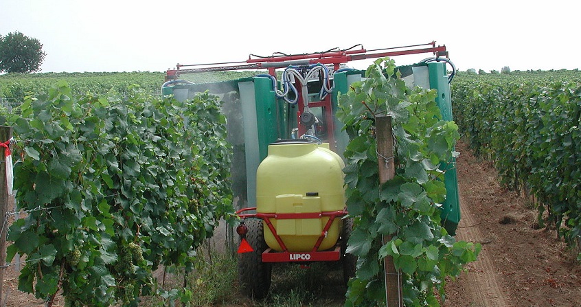
- monocultures (wheat, barley, maize, apples, vines – Figure 9);
- “natural” grasslands (where livestock graze selectively);
- sown meadows;
- … or it allows wastelands to develop…
- In forests that seem natural to us, it favours certain species at the expense of others, eliminates certain layers of vegetation…
- Chemical actions: voluntary application of fertilizers, trace elements, organic amendments (manure, slurry, compost, sewage sludge), calcium (liming), hence the rise in pH and the resaturation of the soil mainly by calcium ions; involuntary inputs of mineral or organic pollutants.
- Repeated inputs of organic or mineral matter (salts contained in irrigation water) that accumulate.
- Human interventions altering completely the initial natural water regime: drainage (by underground pipes or ditch networks), lowering of the water table (marshes, peat bogs), flooding of rice fields, irrigation.
- Agricultural mechanical actions:
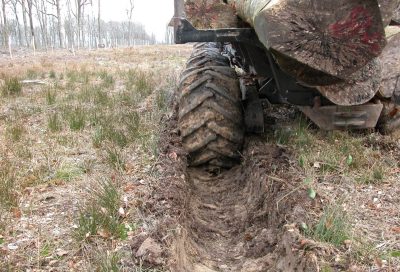
Figure 10. Rutting caused by timber unloading in a forest environment. Deep horizons can be affected by irreversible compaction. [Source: © Jacques Ranger, with the author’s permission] - Ploughing;
- Superficial or deep compaction (Figure 10);
- Subsoiling: tillage of the soil with the aim of loosening it in depth without bringing elements to the surface;
- Very deep ploughing (40 cm to 1 m) carried out exceptionally to dislocate deep indurated horizons or hard rocks located at depth and thus improve the rooting of vines or fruit and forest trees.
- Creation by the farmer of different micro-reliefs raised to avoid excess surface water.These mechanical actions result in the homogenization of the ploughed horizon and sometimes the mixing of horizons
- These mecanical actions result in the homogenization of the ploughed horizon and sometimes the mixing horizons.
- Other mechanical actions (public works): restructuring of steep slopes into terraces more or less narrow (this has been the case since Antiquity), scraping, tarmacking.
- Displacement of earthy materials for the construction of reconstituted urban soils, refitting of abandoned quarries or gravel pits.
7. Duration
Time is a major player, not to be forgotten, in the formation of soils. This is always slow and takes thousands or tens of thousands of years to generate a few decimetres of soil.
Some recent changes are more rapid (on favourable materials) and can affect the upper part of the soil by a few decimetres. For example, from a soil that is already highly acidified, neo-podzolization can only take a century to express itself clearly over about fifteen centimetres.
In northern Europe, many pedogenesis began at the end of the last deglaciation (10,000 – 12,000 years ago). Either the old soils have been completely eroded (e.g. scraped by glaciers), or new surface deposits have formed new parent materials and a new pedogenesis has then begun (new loess or slope formation deposition).
But there are also much older soils. Here are two sets of examples, but there are many more.
- Exemples 1: A certain number of soils are developed in residual clay formations accumulated following the total decarbonatation of calcareous rocks: clay with flint, clay with cherts, clayey and ferruginous soils of the Sinemurian platform in Auxois [4], the “terres d’Aubues” of the plateaus of Lower Burgundy [5] (see Figure 3). All of these soils are at least one to two million years-old (probably more).
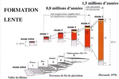
- Examples 2: The soils of the very high terraces of the Rhone pebbly alluvium. The parent material of these deposits consists of fluvio-glacial pebbles from the Alps, containing calcareous stones but also fragments of crystalline rocks. The latter are the main source of all residual weathering products, including clays. Bornand [6] (Figure 11) described 5 stages of pedogenesis that he studied on the various terraces of the middle Rhone valley, dated from the Würm (for the lowest) to the Villafranchian (for the highest). The total evolution time of soils developed in the oldest deposits has been estimated to be between 1.8 and 2.3 million years.
When it comes to soil age, the question is: what soil is it?
To form a Fluviosol Brut, i.e. an alluvium vaguely impregnated with organic matter at its surface (as in the major bed of the Loire), it takes 30 years. To form a Luvisol Typique from a loess deposited at the end of the Würm, it took about 12,000 years. But to form a 15 m thick ferrallitic red soil in Côte d’Ivoire, resulting from the weathering of granites, it took several million years.
8. Messages to remember
- The crossing of the 6 factors of pedogenesis, in particular the great variety of parent materials in France, explains the great diversity of soils that can be observed from one point to another: thickness, colours, texture, particle size contrast, pH, mineralogical composition, richness in organic matter, etc. This also explains their variability in space, which can be very rapid (decametric).
- Man is increasingly an important factor in the modification (morphology and functioning = “artificialization”) or even the total destruction of soils.
- Soils are a non-renewable heritage on the human time scale. Any soil that is totally or partially destroyed is an irreversible loss of patrimony.
Notes et références
Cover image. Tuscany landscape [Source : © Denis Baize]
[1] Baize, D. (2021) Naissance et évolution des sols. La pédogenèse expliquée simplement. Versailles : Éditions Quae, 160 p. (in French)
[2] Jamagne, M. (2011) Grands paysages pédologiques de France. Versailles : Éditions Quae, 598 p (in French)
[3] Robert, M., Berrier, J., Evralde, J. (1983) Rôle des êtres vivants dans les premiers stades de l’altération des minéraux. Sciences Géologiques. Mémoire 73, pp. 95-103. https://www.persee.fr/doc/sgeol_0302-2684_1983_act_73_1_2033 (in French)
[4] Baize, D. et Chrétien, J. (1994) Les couvertures pédologiques de la plate-forme sinémurienne en Bourgogne. Particularités morphologiques et pédogéochimiques. Étude et Gestion des Sols, 1, 2, pp. 7-27. (in French)
[5] Baize, D., (2012) Les « terres d’Aubues » de Basse Bourgogne : nouvelle synthèse et bilan de matières à très long terme. Étude et Gestion des Sols, 19, 3-4, pp. 139-161. (in French)
[6] Bornand, M. (1978) Altération des matériaux fluvioglaciaires, genèse et évolution des sols sur terrasses quaternaires dans la moyenne vallée du Rhône. Thèse, Université de Montpellier 2, 329 p. (in French)
The Encyclopedia of the Environment by the Association des Encyclopédies de l'Environnement et de l'Énergie (www.a3e.fr), contractually linked to the University of Grenoble Alpes and Grenoble INP, and sponsored by the French Academy of Sciences.
To cite this article: BAIZE Denis (January 5, 2025), Six factors of pedogenesis, Encyclopedia of the Environment, Accessed January 21, 2025 [online ISSN 2555-0950] url : https://www.encyclopedie-environnement.org/en/soil/six-factors-of-pedogenesis/.
The articles in the Encyclopedia of the Environment are made available under the terms of the Creative Commons BY-NC-SA license, which authorizes reproduction subject to: citing the source, not making commercial use of them, sharing identical initial conditions, reproducing at each reuse or distribution the mention of this Creative Commons BY-NC-SA license.


