Groundwater in granitic and metamorphic rocks?

PDF
granite - granites - ploumanac'h cotes d’armor - cote granite rose - groundwater in granitic - rocks

Crystalline rocks or “hard” rocks are generally ancient rocks of two main types: plutonic rocks, such as granites, and metamorphic rocks, such as gneiss, schists, micaschists… They are the foundation of all continents and are therefore very common there. Their hydrogeological properties, although recognized at least since the second half of the 20th century, are now very well characterized, thanks to extensive research conducted over the past 20 years. This article describes how these rocks become aquifers, that is, rocks containing groundwater, and then how hydrogeologists proceed to develop, manage and protect their water resources. A focus is dedicated to the case of India where the groundwater resource of crystalline rocks has made a very significant contribution to the “green revolution”.

1. The water resource of crystalline rocks

1.1. Crystalline rocks

chaos granitique - massif du Sidobre - encyclopedie environnement - granitic chaos
Figure 1. Granitic chaos. It corresponds to the outcropping of the lower part of the fractured horizon of an alteration profile. Sidobre Massif, Tarn. [© R. Wyns]
Crystalline rocks or hard rocks” are rocks that are generally ancient, formed at great depth, at several tens of kilometres. They have two different origins.

Plutonic rocks, such as granites (Figure 1), are initially derived from magma (molten rock) that has slowly crystallized at depth.

Metamorphic rocks, such as gneiss, schists, micaschists, etc., were formed by transforming (recrystallizing, deforming, etc.) a pre-existing rock (a sedimentary, volcanic, crystalline rock…) under the effect of temperature and/or pressure.

roches cristallines - roche cristalline - carte roches cristallines - roches cristallines monde - encyclopedie environnement - map crystalline rocks
Figure 2. Location of regions where crystalline rocks are exposed in the world. Orange: crystalline rocks; yellow: other types of rocks; blue: continental ice; white: oceans.

Crystalline rocks were formed mainly in the deep part of the mountain ranges, at a depth of several tens of kilometres, often several hundred million years ago. They were then brought to the surface during the erosion of these landforms. They are therefore the foundation of all continents. They are found outcropping (i.e. near the surface) in many parts of the world (Figure 2 [1]): a very large part of the African, North and South American, Eurasian, two-thirds of India, Australia, etc. In France, they form the so-called “old” massifs: the Armorican Massif, the Central Massif, the Vosges and the Ardennes. They are also well represented in the Pyrenean and Alpine chains, including Corsica, and in several overseas departments or territories (French Guiana, where they constitute almost all the subsoil of this 83,500 km2 department, Saint-Pierre and Miquelon, New Caledonia).

1.2. The challenges and assets of the groundwater resource of crystalline rocks

A rock is aquiferous, i.e. it can contain a groundwater resource, when (1) it has voids (the porosity of the rock), (2) these voids are of sufficient size (at least a few fractions of millimeters thick or diameter) and are connected to each other (the rock is then permeable) and (3) these voids contain water (they are said to be saturated with water), generally provided by precipitation (rain, snow…). This water is then called “groundwater”.

forage aquifere - aquifere - aquifere grabitique - encyclopedie environnement - granitic aquifer
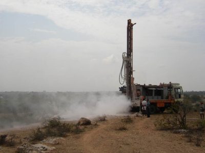
Figure 3 . Drilling in progress in a granitic aquifer using the “down the hole hammer” method. Kothur, Andhra Pradesh, India. [© B. Dewandel]
A modest, but very useful water resource… Crystalline rocks have a medium to low permeability. They therefore contain aquifers with modest water resources compared to porous (sand, gravel, sandstone, etc. sedimentary rocks), karst (limestone rocks) (see karst, renewable water resource in limestone rocks) or volcanic aquifers. Thus, the flow that can be provided by a borehole (Figure 3), or a well, capturing a crystalline aquifer is generally between about 0.5 and 5 m3/h, compared to several tens or even hundreds of m3/h by drilling in other types of aquifers.

This range of flow available in crystalline aquifers still provides water supply for a population of 400 to 4000 people in a developing country (25 l/d/person) and 50 to 500 people in a developed country (200 l/d/person). Exceptionally enough, the flows used can be very high, several tens of m3/h, thus contributing to the supply of drinking water to cities of several tens of thousands of inhabitants (example of the city of Ploemeur, in Brittany).

This groundwater resource is particularly appreciated in semi-arid or arid basement regions, which generally lack sustainable surface water resources (Sahelian regions, India, Northeast Brazil, etc.). They are often the only water resource available to the population. In regions with surface water, such as Guyana or Equatorial Africa, this groundwater resource is often favoured because of its better quality and therefore lower treatment costs.

… easily accessible and inexpensive.
This productivity, which is generally relatively low, is nevertheless offset by certain advantages.
The water resource of basement aquifers is superficial: less than 100 m deep, often only a few tens of metres deep. The cost of drilling is therefore relatively limited: only a few thousand or even hundreds of euros in developing countries (e.g. India). Drilling technologies very well adapted to this type of rock (mainly the “down the hole hammer” technique; Figure 3), robust and of moderate cost, have been developed in recent decades and are well mastered, both in developed and developing countries.

The water resource of basement aquifers is well distributed geographically; i.e. it is almost always possible to drill a well (Figure 3) near a place of consumption (a village, a field to irrigate, etc.), or to multiply drilling to increase overall production. Thus, for example, in India [2], each rice plot often has its own irrigation well, the size of the plot or plots thus supplied being sized according to the flow available for drilling. Another well supplies the neighbouring plot(s) and so on, within the limit of the overall available water resource, which is directly linked to groundwater recharge by precipitation.

This water resource, which is well distributed geographically, is therefore very “decentralized”. As a result, it does not require heavy investments in water supply pipes. Thus, if it is not adapted for large urban areas, this water resource can supply villages and small towns, even districts of large cities, and allows the development of agriculture (irrigation) and industry.

Finally, due to the low permeability of the subsoil of the crystalline regions, a borehole only influences an extension zone limited to its circumference (several tens of metres to a maximum of a few hundred metres), which is low compared to other types of aquifers. Thus, as soon as a well is at a sufficient distance from a watercourse (several tens or hundreds of metres), it has no significant influence on it. Groundwater exploitation then takes place without impact on the flow of the surface watercourse. This is why, in basement regions, unlike in other types of regions, groundwater exploitation can be carried out with a limited impact on surface water flow.

A water resource that also conditions human settlements.
The modest permeability of these rocks also explains why, in crystalline regions well watered by precipitation (e.g. Brittany, Massif Central), the groundwater surface (or piezometric surface – see Figure 5 – the level from which the rock is completely filled with groundwater) is always very close to the ground surface, at a depth of a few metres at most. Indeed, due to this low permeability, the hydraulic gradient (the “slope” of the groundwater surface) is strong and can therefore have a slope that is close to that of the topographic surface. This is reflected in the presence of springs, albeit of modest flow (often less than one l/s at low water levels), in most topographic depressions (especially small valleys) and in a very dense hydrographic network (streams) fed by groundwater. As a result, traditional habitat can be satisfied in the past with these modest water resources (small springs, streams) and was therefore relatively dispersed. Concentrated habitat, requiring greater water resources, was only possible on the banks of the most important perennial rivers.

In less humid crystalline regions, such as sub-Saharan Africa, the groundwater rarely emerges at the surface of the ground. It is then traditionally captured a few metres deep by large diameter wells, which are relatively easy to dig into the altered, loose part of the rock (see its description in section 2).

Thus, unlike karst regions where traditional habitat is concentrated around karst springs, in crystalline regions it is generally much more dispersed.

The following sections of this article present the hydrogeological properties of crystalline rocks and their consequences in operational terms: location of water wells, management and protection of water resources, etc…

2. How do crystalline rocks become aquifers?

Low permeability rocks..
Intrinsically, crystalline rocks have low porosity and permeability. For granitic rocks, this is because the crystallization of the magma that is at their origin left no space available (porosity) in the rock. For metamorphic rocks, this is because the metamorphic processes have completely obliterated the original porosity and permeability of the original rock, if any. For this reason, these low-permeability rocks are often used to store waste, including radioactive waste [3]. Indeed, water can only pass through them with difficulty and therefore cannot easily carry the pollutants contained in this waste outdoors.

fractures granite - granites - ploumanac'h cote d'armor - encyclopedie environnement - fractures granite
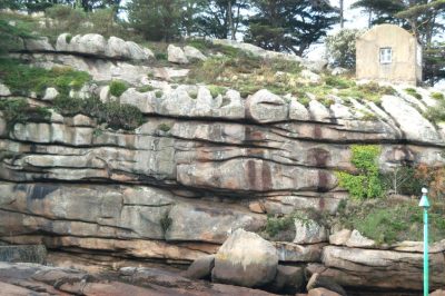
Figure 4. Example of fractures (subhorizontal) within the fractured horizon of a granite. The house on the top right has a maximum height of about 3 m. Ploumanac’h, Côtes d’Armor, France. [© R. Wyns]
… but which become aquifers when they are altered.
Basement rocks only acquire porosity and permeability when they fracture, that is, when stresses are applied to them and they break. Fractures, i.e. breaks in the rock, then form in their midst (Figure 4). From metric to decametric extension, from a few fractions of millimetres to a few centimetres thick, they give the rock a porosity and permeability and therefore make it “aquiferous”. We speak of “fracture permeability”. These permeability acquisition processes have some similarities with those for limestone rocks. The latter are also generally not inherently permeable. They acquire their permeability not by alteration and fracture as basement rocks, but by dissolution.

Hydrogeologists have long thought [4] that these fractures were caused either by tectonics (the stresses that affect the earth’s crust due to the tectonics of the plates) or “decompression” (the principle is to say that bringing a rock to the surface, due to erosion, reduces the pressure within it due to the decrease in the weight of the overlying land, and would lead to it breaking).

In fact, it has been shown that decompression cannot break rocks under the conditions in which we observe it and that plate tectonics can only be invoked in a few very specific situations but cannot explain all the aquifers in basement regions. However, it has been shown that it is the alteration processes that cause fractures [5], [6], [7].

Indeed, when exposed near the ground surface (a few tens or hundreds of metres from it), rocks deteriorate. Rainwater infiltrates and diffuses very slowly into them, imports and exports ions in solution and thus causes changes in the minerals that make up the rocks. Basement rocks are particularly sensitive to these processes. Some minerals, such as biotite (also known as black mica), abundant in basement rocks, have the property of increasing in volume when they undergo such alteration mineralogical transformations. This increase in volume at the scale of the mineral (a few fractions of millimetres) generates stresses at the scale of the rock which, in turn, lead to the appearance of microfractures and then fractures (Figure 4).

schema profil alteration - encyclopedie environnement
Figure 5 – Schematic representation of an alteration profile [7]
The result is what is known as an alteration profile, several tens of metres thick, porous and locally permeable, and therefore aquiferous, which overlies the healthy (unaltered), impermeable rock. To create such an alteration profile, liquid water (i.e. a climate that is neither too arid nor too cold, the water would then be frozen) and time, i.e. several million or tens of millions of years old, are required. It is also necessary that the profile can develop, i.e. that alteration products are not removed by erosion as they form; in fact, alteration profiles are formed in regions with a shallow slope and eroded as they are formed in regions with an over-reaching effect (mountains in formation). In Europe, such alteration profiles were formed at the end of the primary era (Carboniferous and Permian), during the secondary era (Lower Cretaceous) and, more recently, at the beginning of the tertiary era. Remains of such profiles are locally well preserved in all the basement regions of France.

From top to bottom, an alteration profile schematically includes (Figure 5):
* a lateritic or bauxitic armour. Often eroded in metropolitan France, it corresponds to an indurated horizon composed of iron and/or aluminium oxides;

saprolite granite - granites - carriere granite - encyclopedie environnement
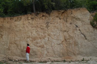
Figure 6. Outcrop of the saprolite of a granite in a quarry. Sartène region, cortica. [Source: © W.Wyns]
  • the saprolite, which can be several tens of metres thick. The original rock is completely transformed by alteration, usually into clay or sandy clay; it is therefore loose (Figure 6). This part of the alteration profile is not very permeable (fractures of the fractured horizon have disappeared, the pores of the rock are small and poorly connected to each other). But it is relatively porous and therefore contains water. Its porosity is between about 1 and 10%, i.e. one cubic metre of rock contains 10 to 100 litres of water; for a thickness of 30 m, there are 300 to 3000 litres of water under each m2. This part of the alteration profile provides groundwater storage;
  • the fractured horizon (Cover image, Figure 1, Figure 4). Its thickness also reaches several tens of meters; it is generally twice as thick as saprolite. Only certain minerals in the rock are altered, so the rock remains hard overall. The fractured horizon has many fractures, which are less frequent as depth increases. It is therefore permeable. This part of the alteration profile allows groundwater flow. Wells or boreholes that intersect one or more permeable fractures at this level have exploitable flows that can reach several cubic metres per hour (m3/h). Since the fractured horizon has a low porosity (of fractures) of about 1%, it contains only a few or tens of litres per m2 over its entire thickness. The water pumped from the boreholes comes mainly from the overlying saprolite after a certain time when it is saturated with water.
  • more deeply, under the fractured horizon, the healthy rock is impermeable; except sometimes, very locally, where certain discontinuities (old fractures of tectonic origin, veins, contacts between different lithologies…) may have guided the alteration more deeply; in this case, the water pumped there also comes from the underlying fractured horizon and saprolite. Overall, with the exception of these few very specific areas, healthy rock does not contain any groundwater resources

In summary, groundwater in basement aquifers is therefore contained within these two horizons: saprolite and fractured horizon. Basement regions where alteration patterns have not formed or have disappeared due to erosion are poor in groundwater.

3. How to exploit and manage groundwater resources in the basement regions?

Knowing where to drill or drill a well to provide groundwater… Modern methods for detecting and mapping alteration profiles, and therefore characterizing the aquifers they contain, have been developed in recent years, and are applicable at all scales, from the scale of a country, region or department as a whole, to the very local scale of a commune, for example

aquifere socle - aquiferes socles - saprolite - encyclopedie environnement
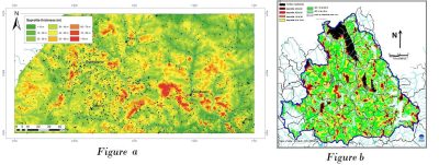
Figure 7. Examples of maps at different scales of the different constituent layers of basement aquifers. Figure a: Thickness of saprolite over a region of about 250 x 100 km in Burkina Faso[8]. Figure b: geological map of the entire alteration coverage over the Lozère basin of the Truyère (Lozère, France, 700 km2): saprolite thickness (increasing thickness from yellow to black, passing through red) and fractured horizon thickness (where saprolite is totally eroded), with decreasing thicknesses from dark green to white (totally eroded fractured horizon), passing through light green [8].
At the scale of a country, a region (Figure 7a [8]), a base department (Figure 7b), hydrogeological mapping makes it possible to design spatial planning policies. Which region (or part of a region) has sufficient groundwater resources and can therefore rely on them for its water supply: drinking water, industry, agriculture? Conversely, which region should seek other sources of supply: surface water from rivers or dams in particular. In a region with groundwater, what is the thickness of the alteration profiles? So ! at what depth should we drill and, consequently, how much will it cost to drill?

Which rocks deteriorate best, which are therefore the most fractured? Where is it best to consider drilling? If it is not in the immediate vicinity of the water use, how much will the supply pipes cost?

What is the probability of intersecting a permeable fracture in the cracked horizon? What is the flow rate of a water well that has intersected one or more of these fractures? So how many boreholes must be drilled to meet given needs? And so what will the cost of the project be?

cartographie couverture alteration - forage granite - aquifere forage - granites - glissement terrain - eau souterraine - carriere - encyclopedie environnement
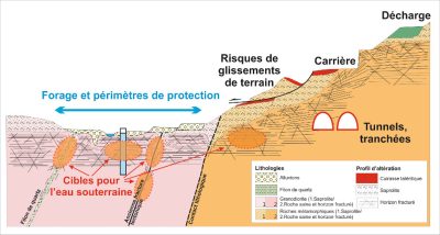
Figure 8. Illustration of various applications of high resolution mapping of alteration coverage at the local scale (Commune of Cacao, Guyana) [8].
At the scale of a commune or village, the hydrogeologist will implement very precise methods: he will carry out field observations on areas where the alteration profile is visible at the surface, he will also implement methods for geophysical auscultation of the subsoil, etc. This allows him to identify, to within a few metres, the most productive fracture zones. At this working scale, it will therefore be necessary to locate as precisely as possible the most favourable sites for positioning groundwater exploitation boreholes (Figure 8).

This precise hydrogeological characterization of the subsoil also allows many other practical applications (Figure 8):

  • beyond the establishment of water wells, the establishment of their protection perimeters;
  • the choice of landfill sites for household waste, on land that meets the legal criteria for impermeability;
  • the location of quarry sites, where the thickness of sterile materials to be stripped is minimal;
  • the characterization of the impact of tunnels [9], which can dry out surface sources and also whose construction can be hampered by excessive groundwater inflows;
  • the consideration of risks of geological origin in land use planning;
  • etc.

Despite these modern methods, some uncertainty remains. Some boreholes do intersect fractures, but they may not be permeable.

… but also to know how to manage this water resource..
Once a well, or a set of wells, has been drilled in a given region (or even better, before drilling), it is necessary to ensure that the available water resource is available.

The hydrogeologist of the basement regions then evaluates the groundwater reserve, i.e. the quantity of groundwater contained in the aquifer (of basement) captured by the drilling, mainly in the saprolite. If we draw a parallel with surface water, the reserve is the quantity of water contained in a dam and therefore the quantity available for exploitation.

However, this estimate is not sufficient. It is also necessary to assess groundwater recharge, i.e. how this reserve is renewed and replenished, usually annually, during the rainy season. If we draw a parallel with surface water again, the recharge is the amount of water from precipitation (rain, snow) that will refill the dam once it is partially or totally emptied. In the case of groundwater, it is the amount of precipitated water that will infiltrate the subsoil. In other words, it is the fraction of precipitated water that escapes evaporation and transpiration from plants (often nearly 50% of precipitation in our temperate latitudes) on the one hand, and surface runoff on the other. In the basement regions, the annual share of infiltrated rainfall ranges from a few percent to 20 to 30%.

The available groundwater resource therefore depends on the proportion, and therefore the quantity, of infiltrated precipitation and the surface (or “catchment area”) that will contribute to the supply of the borehole(s) under consideration. Managing groundwater resources by not exploiting any more than its renewable component ensures the sustainability of exploitation. This is referred to as “sustainable management” of water resources. Aquifers therefore contain a water resource that escapes rapid runoff in the rainy season and remains available for use, particularly in the dry season when surface water is no longer available. The groundwater supply available in basement aquifers corresponds to several years, even 15 to 20 years, of average recharge [10]. This reserve therefore makes it possible to cope with periods of drought. Nevertheless, if it is not managed in a sustainable way, i.e. if it is overexploited, it will run out in a few years.

In order to avoid these risks, different methods and tools for resource management have been developed (see in particular the focus on India). Some of these tools, known as numerical models, are designed to simulate the entire water cycle of a given region. They make it possible to assess the available resource in a chosen catchment area and to construct management scenarios and policies, depending on the geological and hydrogeological structure of the subsoil, climatic conditions, water uses, impacts considered acceptable, in particular with regard to reducing the flow of rivers due to groundwater exploitation, etc. These numerical models were first developed for sedimentary aquifers. In France, sedimentary basins have been modelled, such as the Aquitaine basin and the Paris basin for example. The development of the concepts presented above has made it possible to apply similar models for basement aquifers.

… and protect it
The knowledge of the subsoil as described above also makes it possible to map the preferential recharge areas of basement aquifers and to determine in particular the ability of the soil to retain or purify pollutants.

This allows spatial planning policies to be proposed to protect groundwater, for example by avoiding polluting activities in areas where soils have a low purifying power. Effective protection measures, or even measures to restore groundwater quality in areas where it is degraded, can also be implemented.


References and notes :

Cover image. The ,fractured horizon of granites exposed on the surface at Ploumanac’h, Côtes d’Armor, on the pink granite coast [Source : © R. Wyns]

[1] Lachassagne, P., Dewandel, B., Wyns, R. (2014a). Hydrogeology of Hard Rock aquifers. In Hanbbook of Engineering Hydrology. Fundamentals and Applications. Edited by S. Eslamian. CRC Press, Taylor & Francis Group, Chapter 14, pp. 282-310

[2] Dewandel, B., Perrin, J., Ahmed, Sh., Aulong S., Hrkal Z., Lachassagne P., Samad M., Massuel S. 2010. Development of a Tool for managing groundwater resources in semi-arid hard rock regions. Application to a rural watershed in south India. Hydrological Processes. 24, 2784-2797

[3] Storage of nuclear waste in crystalline rocks (Sweden and Finland) http://www.skb.com/, http://www.posiva.fi/en

[4] Lachassagne, P., Wyns, R., Dewandel B., 2011. The fracture permeability of Hard Rock Aquifers is due neither to tectonics, nor to unloading, but to weathering processes. Terra Nova, 23, 145-161,2011

[5] Wyns, R., Gourry, J.-C., Baltassat, J.M., Lebert, F., Multiparameter characterization of subsurface horizons (0-100 m) in altered basement context, PANGEA 31/32: 51-54, 1999

[6] Wyns,R., Baltassat, J.M., Lachassagne, P., Legchenko, A., Vairon, J., Mathieu, F., ñ ñ ñ ñ ñ ñ Application of SNMR soundings for groundwater reserves mapping in weathered basement rocks (Brittany, France) ñ Bulletin de la Société Géologique de France 175, (1), 21-34, 2004

[7] Lachassagne, P., Dewandel, B., Wyns, R. (2014b). The conceptual model of weathered hard rock aquifers and its practical applications, ,in “Fractured Rock Hydrogeology”, N°20 International Association of Hydrogeologists Selected Papers, Editor J. M. Sharp, Jr, CRC Press, Taylor and Francis Group, pp. 13-46

[8] Lachassagne, P., Dewandel, B., Wyns, R. (2014b). The conceptual model of weathered hard rock aquifers and its practical applications, in “Fractured Rock Hydrogeology”, N°20 International Association of Hydrogeologists Selected Papers, Editor J. M. Sharp, Jr, CRC Press, Taylor and Francis Group, pp. 13-46

[9] Dewandel et al., 2017. Dewandel, B., Caballero, Y., Perrin, J., Boisson, A., Dazin, F., Ferrant, S., Chandra, S., Marechal, J.C. 2017. A methodology for regionalizing 3-D effective porosity at watershed scale in crystalline aquifers. Hydrological Processes. 2017;1–19. DOI: 10.1002/hyp.11187

[9] Lachassagne, P., Maréchal, J.C., Bienfait, P., Lacquement, F., Lamotte, Cl. 2014. Computing the water inflows discharge and assessing the impacts of tunnels drilled in Hard Rocks. IAEG XII Congress, Torino 2014. G. Lollino et al (eds.), Engineering Geology for Society and Territory – Volume 3. DOI: 10.1007/978-3-319-09-09054-2_119, © Springer International Publishing Switzerland 2015, pp. 595-599


The Encyclopedia of the Environment by the Association des Encyclopédies de l'Environnement et de l'Énergie (www.a3e.fr), contractually linked to the University of Grenoble Alpes and Grenoble INP, and sponsored by the French Academy of Sciences.

To cite this article: LACHASSAGNE Patrick, DEWANDEL Benoît, WYNS Robert (February 7, 2019), Groundwater in granitic and metamorphic rocks?, Encyclopedia of the Environment, Accessed December 26, 2024 [online ISSN 2555-0950] url : https://www.encyclopedie-environnement.org/en/water/groundwater-in-granitic-and-metamorphic-rocks/.

The articles in the Encyclopedia of the Environment are made available under the terms of the Creative Commons BY-NC-SA license, which authorizes reproduction subject to: citing the source, not making commercial use of them, sharing identical initial conditions, reproducing at each reuse or distribution the mention of this Creative Commons BY-NC-SA license.

花岗岩和变质岩中的地下水?

PDF
granite - granites - ploumanac'h cotes d’armor - cote granite rose - groundwater in granitic - rocks

  结晶岩或“硬”岩一般是指两种主要类型的古老岩石:一种是深成岩,如花岗岩;一种是变质岩,如片麻岩、片岩、云母片岩。这些岩石是所有陆地的基础,因此非常常见。这些岩石的水文地质学性质,尽管最早是从20世纪下半叶开始被认识和研究的,通过过去20年的大量研究,目前已得到了很好的表征。本文讲述了这些岩石是怎样演变成含水层,即含地下水的岩石,以及水文地质学家如何开发、管理和保护这些水资源。同时重点讲述一个印度的案例,其结晶岩中的地下水资源对“绿色革命”发挥了非常重要的作用。

1. 结晶岩中的水资源

1.1. 结晶岩
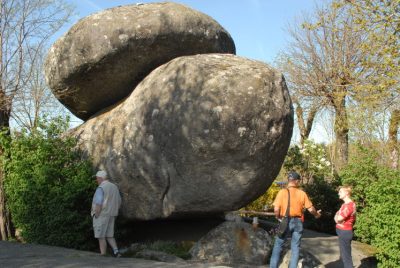
环境百科全书-岩石-花岗岩型杂乱
图1. 花岗岩型杂乱。其对应蚀变面中断裂层中较低的部分露出地面。锡多布尔地区,冰斗湖。[©罗伯特·温斯]

  结晶岩或“硬岩”是那些通常很古老的岩石,形成于几十公里深处,包括有两种不同的起源。

  深成岩,如花岗岩(图1),由岩浆(熔化的岩石)在深处缓慢结晶而形成。

  变质岩,如片麻岩、片岩、云母片岩等,是在温度和/或压力的作用下,由原有的岩石(沉积岩、火山岩、结晶岩)通过转化(再结晶、变形等)而形成的。
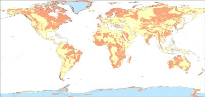
环境百科全书-岩石-结晶岩暴露区域分布
图2. 全球结晶岩暴露区域分布。橙色:结晶岩;黄色:其他类型岩石;蓝色:大陆冰川;白色:海洋。

  结晶岩一般形成于几亿年前,主要在深度达几十公里的山脉深处。在地貌侵蚀过程中,这些岩石被带到地表,因此形成了陆地大洲的基础。它们在世界上许多地方裸露出来(图2 [1]):非洲的一大部分、美洲、欧亚大陆、印度的三分之二和澳洲等。在法国,它们形成了常说的“年代久远的”地区:阿摩里卡丘陵,法国中央高原,孚日山脉,阿登高原。同时它们也存在于比利牛斯山脉和阿尔卑斯山脉,包括科西嘉岛,以及一些海外领地(法属圭亚那,在那里结晶岩占据了几乎全部8.35万平方公里的表土区域、圣皮埃尔和密克隆群岛、新喀里多尼亚)。

1.2. 结晶岩地下水资源的挑战和价值

  当岩石(1)含有孔隙(岩石孔隙),(2)孔隙尺寸足够大(厚度或直径至少几分之一毫米)同时互相连通(岩石因此是透水的),(3)这些孔隙含有补充自降水(雨、雪等)的水(此状态被称为水饱和状态)时,岩石是含水的,即其包含地下水资源。此时这些水被称为“地下水”。
环境百科全书-岩石-潜孔锤法钻探
图3. 使用“潜孔锤”法对花岗岩含水层进行钻探。安得拉邦,印度。[©贝努瓦·德万德尔]

  一种有限但非常有用的水资源…结晶岩的渗透率中等或较低。相对于多孔介质(砂、砾石、砂岩等沉积岩)、岩溶(石灰岩)(见“岩溶,石灰岩中的可再生水资源”)和火山岩含水层,结晶岩含水层的水资源含量有限。结晶岩含水层中一个钻孔(图3)或一口井能够提供的水流量通常在0.5到0.5到5立方米每小时,而其它类型的含水层中的水流量达到几十甚至几百立方米每小时。

  结晶岩含水层的这一水流量范围对应发展中国家400至4000人(25升/天/人)和发达国家50到500人(200升/天/人)的用水需求。在一些很特殊的情况下,水量可以很充足,能达到几十立方米每小时,能够为拥有数万名居民的城市提供饮用水(如布列塔尼的普洛埃默尔城)。

  这种水资源在那些缺乏可持续的地表水资源的干旱和半干旱地区(印度萨赫勒地区、巴西东北部等)尤其重要,它们通常是当地居民唯一的可利用的水资源。而在一些有地表水资源的地区(比如圭亚那和赤道非洲),这种地下水由于其更好的水质和更低的处理成本,也被大家所青睐。

  方便取用且便宜。

  结晶岩含水层相对较低的产水能力问题能够被一些优势所抵消。

  基底含水层的水资源是较浅的,其深度不超过100米,一般只有几十米深。钻探的成本相对较低,在发展中国家(如印度)仅需花费几千甚至几百欧元。

  那些很适用于这类岩石的钻探技术(主要是“潜孔锤”技术,图3),经久耐用且成本适中,在近几十年发展迅速,并且目前发达国家和发展中国家都很好地掌握了这门技术。

  基底含水层的水资源在地理上分布较好,几乎可以在任何需要用水的地方(村庄、灌溉地等)附近钻井(图3)或者通过多井钻探来增加总流量。以印度为例[2],通常每一块稻田都有自己的灌溉井,所灌溉的田块的大小决定于钻井的流量。一口井灌溉一块田地,一块接一块。灌溉井的数目决定于总的可用水资源的量,而该水资源量又与降水补给地下水直接相关。

  由于这种水资源在地理上分布较好,因此十分“分散”。因此,获取这些水资源不需要在供水管道方面进行大量投资。即便在大的城区无法适用的话,这些水资源可供给乡镇地区,甚至大城市的部分区域,保障农业(灌溉)和工业发展。

  此外,由于结晶岩区域底土的水渗透性较低,相对于其他类型的含水层来说,此区域下钻孔对周围区域的影响范围较小(几十米到最多几百米)。因此,只要保证钻井和水道有着足够的距离(几十到几百米),地下水的开采就不会影响到地表水的水道流动。与其他类型的区域不同,由于对地表水流的影响较小,在这种基底区域中能够进行地下水开采。

  制约人类居住环境的水资源

  这些岩石的中低渗透性也能够解释为什么在降水丰富的结晶岩区域中(例如布列塔尼、中央高原),地下水面(或测压面-见图5-岩石完全被地下水填满的水位)与地面很近,深度最多只有几米。也正是由于低渗透性,其水力坡度(地下水面的“坡度”)较大,接近地形表面。这一点反映在泉水普遍存在于大多数地形洼地(尤其是小山谷)和地下水供给十分密集的水文网络(溪流)中,尽管水流量通常不大(低水位时流量常小于1 L/s)。因此,需水量一般(小型泉水和溪流即可满足)的传统的居住地相对比较分散;而需水量更大的集中居住地一般只会存在于常年性河流的河岸附近。

  在欠湿润的结晶岩区域,如撒哈拉以南非洲,地下水很少能冒出地表。传统上,这些地区一般通过开挖几米深的大直径井获取地下水,开挖区域岩石蚀变严重,较为松散,工作进行相对容易(见第2节)。

  因此,不像在石灰岩地区,传统的居住地一般集中在岩溶泉水附近,在结晶岩区域,居住地分布更为分散。

  本文下面部分介绍了结晶岩的水文地质特征及其对钻探的影响相关内容:水井的位置、水资源的管理和保护等…

2. 结晶岩是怎样变成含水层的?

  低渗透性岩石…

  结晶岩本身而言具有低孔隙率和渗透性。对于花岗岩来说,这是因为岩浆结晶形成岩石的过程未给岩石剩下足够的空间(孔隙)。对于变质岩来说,这是由于变质过程使得其母岩中可能存在的原始孔隙和渗透率完全丧失。正是由于这样的原因,这些低渗透性岩石通常被用来储存废弃物,包括放射性废弃物[3]。因为水很难渗透流过这一类岩石,因此不容易将储存其中的污染物带到外界环境中。
环境百科全书-岩石-花岗岩断裂层裂隙示例
图4. 花岗岩断裂层(水平)裂隙示例。 右上角房屋高度最多为3米。普卢马纳赫,阿摩尔滨海,法国 [©罗伯特·温斯]

  …但是当它们蚀变后就变成了含水层。

  基岩受到压力时就会断裂,只有在破裂后才会生成孔隙并具有渗透性。裂隙,即岩石断裂,会在其中形成(图4)。延伸长度从几米到几十米,宽度从几分之一毫米到几厘米,这些裂隙使得岩石形成孔隙并具有渗透性,进而使得其成为“含水的”。我们称之为“裂隙渗透性”。这种渗透性的形成过程和一些石灰岩渗透性的形成过程有一些相似之处:后者通常也不是本身具有渗透性;不过它们的渗透性不是来源于基岩蚀变和断裂过程,而是由于溶解过程。

  长期以来,水文地质学家们认为[4]这些裂隙或是由于地质构造(源于板块构造并影响地壳的应力)或是由于“降压”(其原理是由于侵蚀作用,将岩石带到了地表,而由于上层覆盖土地的重量下降从而降低其中的压力,进而导致断裂)造成的。

  事实上,有研究表明在我们所观察到的条件下“降压”无法使得岩石断裂;而板块地质构造只能在一些非常特殊的情况下起作用,并不能解释所有基岩区域的含水层情况。然而,目前已经表明,正是由于蚀变过程导致了断裂 [5][6][7]

  当岩石暴露在靠近地表位置时(距离地表几十或几百米),岩石会发生变化。雨水缓慢地渗入并扩散到岩石中,通过溶液不断进行离子交换,进而导致组成岩石的矿物组分发生变化。这一过程对于基岩的影响十分明显。一些矿物,例如黑云母(也被称为黑色云母),在基岩中含量丰富,当它们经历这种蚀变矿物转化过程时体积会增大。在矿物尺寸级别的体积增加(约几分之一毫米)的情况在岩石尺度上将产生应力,导致微裂隙的出现,进而发生岩石断裂(图4)。

  这一作用导致了蚀变纵断面的形成。蚀变层厚度达几十米,多孔且局部具有渗透性,因此是含水的,并且覆盖在原始(未发生蚀变)且不透水的岩石上。要形成这样的蚀变纵断面,液态水(既不太干旱也不太寒冷的气候条件,否则水会挥发或者冻结)和时间(约几百万到几千万年的历史)是必要条件。此外,蚀变纵断面可以不断增长也是必要的,即蚀变的产物在形成后不会由于侵蚀作用转移。实际上,蚀变纵断面形成于坡度较浅的区域;在受“过度延伸”效应(山脉的形成)影响的区域,蚀变纵断面形成后会被侵蚀。在欧洲,此类蚀变纵断面形成于古生代末(石炭纪和二叠纪)、中生代(下白垩纪)以及新生代初期。这种纵断面的遗迹在法国的基岩区域都保存较好。

  由上至下,蚀变纵断面包括有(图5):

* 红壤或铁铝氧石层。在法国本土地区,这一层常被侵蚀,其对应于由铁和/或铝氧化物组成的硬化层;
环境百科全书-岩石-花岗岩的裸露腐泥土
图6. 采石场中花岗岩的裸露腐泥土。萨尔泰讷地区,科西嘉。[来源:©罗伯特·温斯]
  • 腐泥土,其厚度可达几十米。母岩经蚀变作用完全转化为粘土或砂粘土;因此其质地较为松散(图6)。这部分蚀变纵断面的渗透性较差(断裂层位的裂隙已经消失,岩石的孔隙小且连通性较差)。但其相对是多孔的,因此含有水。其孔隙度大约在1%到10%之间,即一立方米的岩石中含有10到100升水;以30米的厚度来计算的话,每平方米下含有300至3000升水。这部分的蚀变纵断面提供地下水存储;
  • 断裂层(封面图,图1,图4)。其厚度也达到了几十米,通常为腐泥土的两倍。由于其中仅部分矿物发生变化,所以岩石整体仍然保持坚硬状态。断裂层有许多裂隙,裂隙的数量随着深度的增加而减少。因此断裂层是具有渗透性的。地下水可以在这部分蚀变纵断面中流动。挖井或者钻孔至一个或多个这种渗透级别的裂隙,其可开采流量可以达到每小时几立方米。由于断裂层孔隙度(裂隙)较低,仅约1%,每平方米下整个断裂层的水量仅为几升或几十升。若腐泥土层富含水,在一定时间后,从钻孔中抽取的水主要来自于其上层的腐泥土。
  • 更深处,在断裂层以下,母岩是不透水的;但有时,在很少的局部地区,母岩的不连续性(地质构造本身的旧裂隙、纹理、不同岩性之间的界面…)可能导致更深的蚀变;在这种情况下,其中可抽取的水也是来自断裂层和腐泥土。总的来说,除了这几个特定区域,母岩中不包含任何地下水资源。

  总之,基底含水层中的地下水主要存在于两个区域:腐泥土和断裂层。在蚀变纹理未形成前或因侵蚀作用导致蚀变消失的基底区域,地下水较贫乏。

3. 怎样开发和管理基底区域的地下水资源?

  确定在哪里钻孔或者钻井能够获取地下水…近些年开发的探测和绘制蚀变纵断面的现代方法,能够表征其中包含的含水层,适用于所有的尺度,从一个国家、地区或者行政区到最小行政区。
环境百科全书-岩石-基底含水层示例图
图7. 不同比例尺下不同组成层的基底含水层示例图。图a:布基纳法索地区约250×100 公里区域的腐土层厚度[7]。图b:特鲁耶尔地区洛泽尔盆地(洛泽尔,法国,700 平方公里)整个蚀变区域的地质图:腐泥土厚度从黄色到红色再到到黑色,厚度逐渐增加;断裂层厚度(腐泥土被完全侵蚀),从深绿到浅绿再到白色(断裂层被完全侵蚀)厚度逐渐降低[7]

  从国家、地区(图7a [7])和行政区(图7b)尺度,绘制水文地质图使得设计空间规划政策方案成为可能。哪个地区(或地区的一部分)有充足的地下水资源,能够依靠其为饮用水、工业、农业供水?相反地,哪个地区需要寻找其他供水来源,尤其是河流或水坝的地表水。在有地下水的地区,蚀变纵断面的厚度是多少?同时,我们钻探的深度需要达到多少?钻探的成本是多少?

  哪些岩石变化程度最大,从而断裂程度最大?最佳的钻探位置在哪?如果不是紧邻用水地区,供水管道的费用是多少?

  在断裂区中钻井,与可渗透裂隙相交(连通)的概率是多少?一口与一个或者多个裂隙相交的水井的水流量为多少?需要多少钻孔才能够满足给定的用水需求?以及这个项目的成本是多少?
环境百科全书-岩石-蚀变覆盖层的应用图解
图8. 局部尺度上绘制高分辨率蚀变覆盖层的各种应用图解 (可可,圭亚那)[7]
Décharge 倾倒,Carrière 采石场,Risques de glissements de terrain 滑坡风险,Forage et périmètres de protection 钻探和保护范围,Tunnels, tranchées 隧道,沟渠,Cibles pour l’eau souterraine 可利用地下水,Lithologies 岩性,Alluvions 冲积岩,Filon de quartz 石英,Granodiorite (1.Saprolite/2. Roche saine et horizon fracture) 花岗闪长岩(1.腐岩/2.母岩和断裂层),Roches metamarphiques (1.Saprolite/2.Roche saine et horizon fracture) 变质岩(1.腐岩/2.母岩和断裂层),Profil d’altération 风化剖面图,Cuirasse latéritique 红土层,Saprolite 腐岩,Horizon fracture 断裂层

  在公社或者村庄尺度上,水文地质学家采用非常精确的方法:对地表可见的蚀变纵断面所在区域进行实地观测,同时对底土进行地质物理分析,等等。这能够帮助其识别误差在几米以内的高产断裂带。在这种工作尺度下,有必要对最合适的地下水开采钻孔位置进行尽可能精确的定位(图8)。

  这种对于底土的精确水文地质表征还能够支撑许多其他的实际应用(图8):

  • 在钻建水井的时候,同时建立其保护范围;
  • 在符合防渗相关法律标准的土地上进行生活垃圾填埋场的场址选择;
  • 采石场位置的确定,在该位置处被采石料的厚度尽可能小;
  • 隧道影响的表征[8],隧道的建设会使得接近地表的水资源干涸,同时地下水的过量渗入也会影响隧道的建设;
  • 土地利用规划中,地质原因风险的考虑;
  • 等等。

  尽管有这些先进方法,不确定性仍然存在。一些钻孔确实钻至裂隙处,与其相交,但这些裂缝可能并不具有渗透性。

  也需要知道如何管理这些水资源…

  一旦在某区域钻一口井或一组井(或者更好是在钻探之前),就必须保证水资源的可利用性。

  委派至相关基底区域的水文地质学家会评估地下水储量,即通过钻井可以获得的含水层(基底)地下水量,主要是腐泥土层的水量。我们可以将地下水类比于地表水,地表水的储量即为河坝中的水量,而这一水量也就是可供开采利用的水量。

  然而,这样估算是不够的。还需要评估地下水的补给,即这些储量是怎样在雨季(一般一年一次)得到更新和补充的。我们可以再次将地下水类比于地表水,地表水的补给是指在大坝水资源部分或完全耗尽后,那部分将大坝重新填满的降水(雨、雪)量。就地下水而言,它的补给是指那部分渗过底土的降水量。也就是说,地下水的补给是指总降水除去由蒸发和植物蒸腾作用消耗的降水量(在温带地区通常占近50%),以及除去地表径流量。在基底区域,降雨下渗为地下水资源的量的年均比例从几个百分点到20%至30%不等。

  因此,可利用的地下水资源量取决于渗入地下的降水的比例和量,以及补给区的地表(或“集水区”)面积。通过避免过度开采(即仅开采可再生部分)来管理地下水资源可以确保开采的可持续性。这被称为水资源“可持续管理”。含水层中在雨季储存的水资源,不像地表径流那样会快速流走,而是能够被有效利用,尤其在地表水资源欠缺的旱季。地下含水层中可利用的水资源量相当于其年均补给量的几倍(甚至15到20倍)的水平[9]。地下水储量大,因此能够应对干旱时期的缺水问题。然而,如果不对其进行可持续性的管理,即过度开发利用,这些资源会在几年内被耗尽。

  为了避免这些风险,目前已经开发出了许多水资源管理的方法和工具(值得关注印度在这方面的许多做法)。这些工具中的数学模型,旨在模拟给定区域的水文循环。通过分析底土的地质学和水文地质结构、气候条件、水资源利用、可接受的影响,尤其是地下水开采导致的河流流量的下降等,这些模型能够在评估指定集水区域的可利用资源量以及构建管理体系和政策中发挥重要作用。这些数学模型最初是为了沉积岩含水层而开发的。目前在法国,已对阿基坦盆地和巴黎盆地等沉积岩盆地进行了相关建模。上述相关的发展使得将类似模型在地下含水层的应用得以实现。

  保护它

  上述的底土知识还能支撑地下含水层优先补给区的绘制工作,并且能够为土壤截留或净化污染物的能力提供依据。

  这能够帮助制定空间规划政策来保护地下水,例如避免在土壤净化能力较低的区域从事造成污染的相关活动。还应采取有效的保护措施,甚至应采取措施恢复地下水退化地区的地下水质量。


参考资料及说明

封面图片:阿摩尔滨海省普卢马纳赫粉红黄岗岩海岸地表裸露的花岗岩断裂带 [来源:©罗伯特·温斯]

[1] Lachassagne, P., Dewandel, B., Wyns, R. (2014a). Hydrogeology of Hard Rock aquifers. In Hanbbook of Engineering Hydrology. Fundamentals and Applications. Edited by S. Eslamian. CRC Press, Taylor & Francis Group, Chapter 14, pp. 282-310

[2] Dewandel, B., Perrin, J., Ahmed, Sh., Aulong S., Hrkal Z., Lachassagne P., Samad M., Massuel S. 2010. Development of a Tool for managing groundwater resources in semi-arid hard rock regions. Application to a rural watershed in south India. Hydrological Processes. 24, 2784-2797

[3] Storage of nuclear waste in crystalline rocks (Sweden and Finland) http://www.skb.com/, http://www.posiva.fi/en

[4] Lachassagne, P., Wyns, R., Dewandel B., 2011. The fracture permeability of Hard Rock Aquifers is due neither to tectonics, nor to unloading, but to weathering processes. Terra Nova, 23, 145-161,2011

[5] Wyns, R., Gourry, J.-C., Baltassat, J.M., Lebert, F., Multiparameter characterization of subsurface horizons (0-100 m) in altered basement context, PANGEA 31/32: 51-54, 1999

[6] Wyns,R., Baltassat, J.M., Lachassagne, P., Legchenko, A., Vairon, J., Mathieu, F., ñ ñ ñ ñ ñ ñ Application of SNMR soundings for groundwater reserves mapping in weathered basement rocks (Brittany, France) ñ Bulletin de la Société Géologique de France 175, (1), 21-34, 2004

[7] Lachassagne, P., Dewandel, B., Wyns, R. (2014b). The conceptual model of weathered hard rock aquifers and its practical applications, in “Fractured Rock Hydrogeology”, N°20 International Association of Hydrogeologists Selected Papers, Editor J. M. Sharp, Jr, CRC Press, Taylor and Francis Group, pp. 13-46

[8] Dewandel et al., 2017. Dewandel, B., Caballero, Y., Perrin, J., Boisson, A., Dazin, F., Ferrant, S., Chandra, S., Marechal, J.C. 2017. A methodology for regionalizing 3-D effective porosity at watershed scale in crystalline aquifers. Hydrological Processes. 2017;1–19. DOI: 10.1002/hyp.11187

[9] Lachassagne, P., Maréchal, J.C., Bienfait, P., Lacquement, F., Lamotte, Cl. 2014. Computing the water inflows discharge and assessing the impacts of tunnels drilled in Hard Rocks. IAEG XII Congress, Torino 2014. G. Lollino et al (eds.), Engineering Geology for Society and Territory – Volume 3. DOI: 10.1007/978-3-319-09-09054-2_119, © Springer International Publishing Switzerland 2015, pp. 595-599


The Encyclopedia of the Environment by the Association des Encyclopédies de l'Environnement et de l'Énergie (www.a3e.fr), contractually linked to the University of Grenoble Alpes and Grenoble INP, and sponsored by the French Academy of Sciences.

To cite this article: LACHASSAGNE Patrick, DEWANDEL Benoît, WYNS Robert (March 9, 2024), 花岗岩和变质岩中的地下水?, Encyclopedia of the Environment, Accessed December 26, 2024 [online ISSN 2555-0950] url : https://www.encyclopedie-environnement.org/zh/eau-zh/groundwater-in-granitic-and-metamorphic-rocks/.

The articles in the Encyclopedia of the Environment are made available under the terms of the Creative Commons BY-NC-SA license, which authorizes reproduction subject to: citing the source, not making commercial use of them, sharing identical initial conditions, reproducing at each reuse or distribution the mention of this Creative Commons BY-NC-SA license.