Learning to live with rivers, a matter of geomorphology
PDF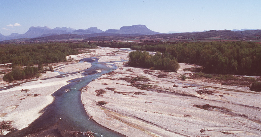
How and why do river beds change? At the interface of several disciplines, geomorphology studies this very particular environment and leads to essential recommendations. What are the threats to this or that river, to the quantities of solid materials it transports, to its ecological environment in the valley it irrigates? The case of large rivers, such as the Rhone, equipped with major facilities, attracts constant attention. It now leads specialists to simulate their evolution in order to promote sustainable management.
1. What is a river bed?

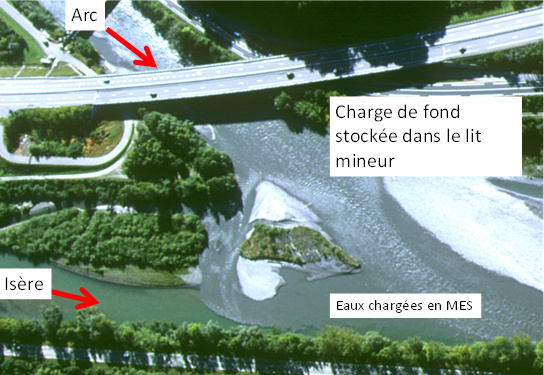
Sediments and floats move downstream at variable speeds. The bottom load may not move or very rarely. In mountain rivers, it can move much more frequently and farther, travelling several hundred metres during a flood. On the other hand, suspended or floating matter will travel several hundred km during the same event. This solid transport is governed by the physical properties of the water body, such as the flow velocities that keep particles in suspension, preventing their deposition, or the tractive forces or friction stresses that allow the movement and transport of the coarser sediments on the bottom.
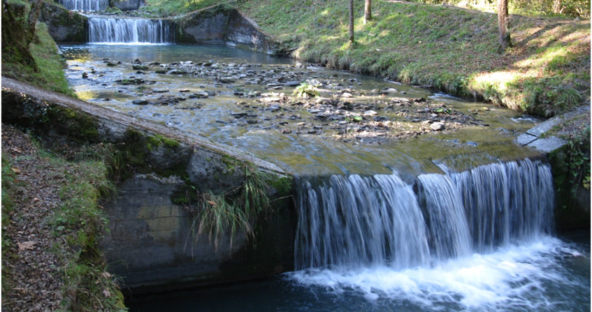
There are a variety of river beds depending on the slope and flow rate that control the power of the current and the sediment load transported. The geological environment crossed also influences the characteristics of the river beds by influencing their resistance. The bed can be drawn in the sediments it carries (alluvial beds) or in the bedrock (rocky beds).
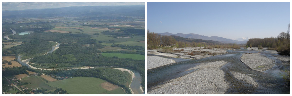
The bed has style! The river style corresponds to the plan of the channel. The channel may be frozen or more mobile in its plain, as the processes of erosion, deposition and sediment transport are more active. This sensitivity to movement is related to the fact that the watercourse has energy and its bed is not very resistant.
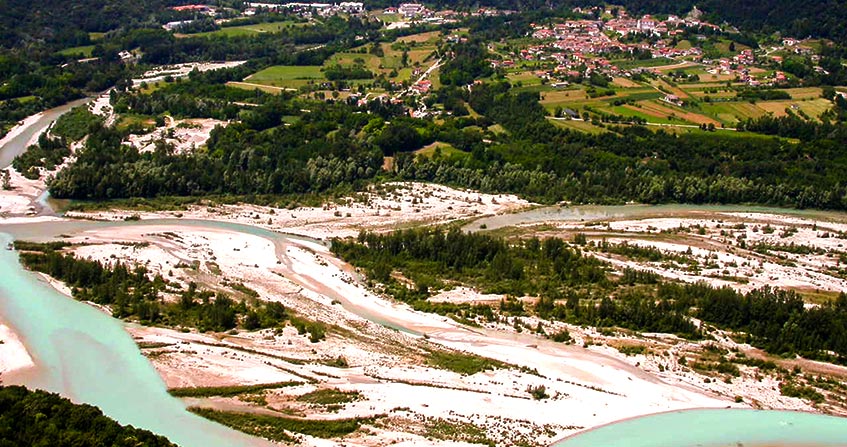
The watercourse can be single-channel and more or less sinuous, forming meanders, large curves in the plain (Figure 3). When the river has a winding or meandering bed, flow velocities are then asymmetric in the channel. Strong in concave banks, they favour their erosion. Weaker on the convex shoreline, they favour the formation of a bank resulting from the deposition of sediments torn from the concave bank immediately upstream. On meandering rivers in foothills areas such as the Allier [1] or the Ain, this meandering dynamic is active because the slope is still marked, and the channel thus moves in its plain.
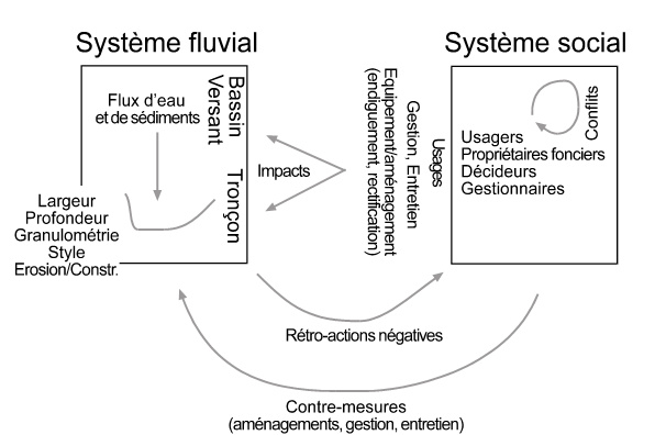
The river is also a mosaic of ecosystems (water body, riparian environments, underground compartment). It is also a geographical space that belongs to someone, to a private person, to a municipality, and to the State for the older ones. The river has specific resources (aggregates, water, hydroelectricity). It is a space on which uses are exercised (fishing, navigation, leisure) and where there are sometimes conflicts (water sharing, development choices). It is also a risk area (pollution, flooding, bank erosion). The issues are more or less complex depending on the geomorphology of the river, the size of the alluvial plain, the dynamics of environmental renewal and the sensitivity of the channel to change.
2. From riverbed to river geomorphology
River geomorphology is concerned with geometry, the forms in which water, sediments and floats pass through, but also the processes of erosion, deposition and transport of sediments that govern these forms (See Focus 1, What is geomorphology).
Initial work has thus shown that the minor bed is primarily conditioned by current floods. This gave rise to a field of research around hydraulic geometry following work carried out by Leopold and Wolman. These authors are often considered to be the pioneers in the field. The book Fluvial Processes in Geomorphology [2], first published in 1964, is a reference. The flow that shapes the minor bed or morphogenic flow has since been considered as the full-body flow, i.e. the flow that just overflows over the banks and has a return period of 1 to 2 years. The bed of an alluvial river is thus shaped by current floods and not by exceptional events.
Long considered as a physical entity governed by water and sediments, conditioned by upstream controls (sediment sources and hydro-climatic cycle of the catchment area and their anthropogenic disturbances), the river bed also has a biological component that influences its form (read Alpine alluvial Landscape and biodiversity)
A bed is the result of a complex balance between flow and resistance forces. The energy of the water depends mainly on the water level and the slope of the channel. The resistance of the bed depends on the size of the sediments that make up the bed. These are more or less heavy, cohesive, nested, and therefore more or less difficult to move by flow, to erode. Resistance also depends on the living and dead vegetation in the bed and on its margins. Root systems are more or less effective in arming the banks, retaining sediments and thus limiting erosion.
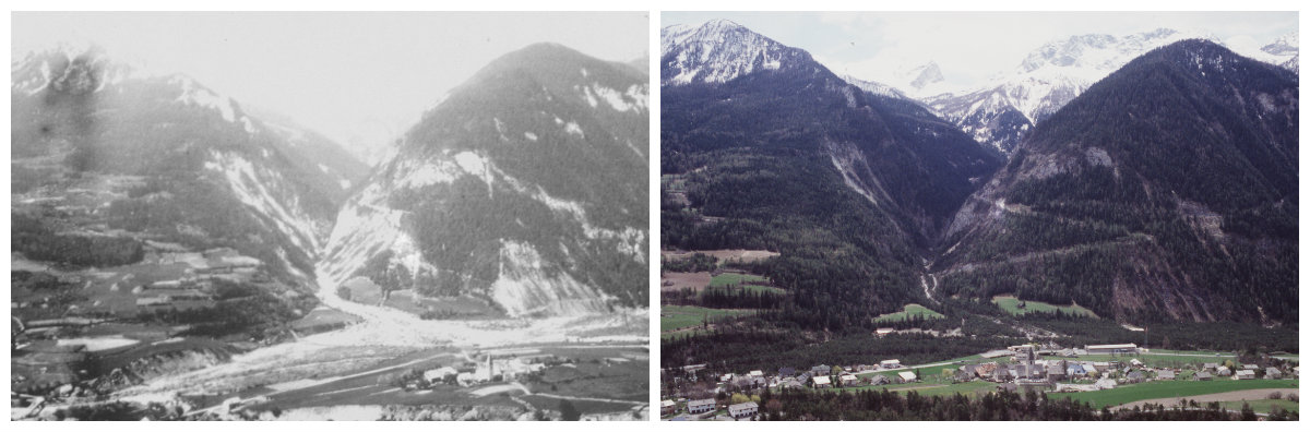
The dynamics of plant colonization and growth is also an important factor that controls the resistance of a riverbed. Competition between species or biological invasion mechanisms may favour individuals that may be more or less resistant to flow. These factors are ecological and biological mechanisms that explain why the shape of a watercourse is not only a matter of physics. This is particularly the case in temperate environments where plant dynamics are active and where human actions have a significant influence on these dynamics. We are obviously thinking of deforestation, which can completely destabilize the slopes, significantly increase sedimentary inputs to rivers and profoundly transform their geometry. Single, stable and winding beds can thus give way in the plain to very mobile braided beds.
3. Geomorphology, risk management, environmental quality and sustainable development
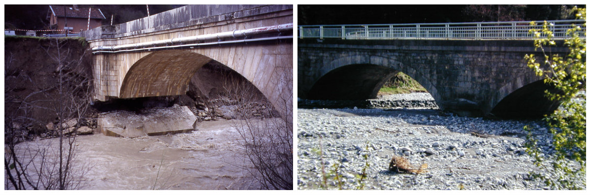
The flood regime may also have changed. Flooding is more frequent because the watershed has become less permeable due to urbanization. This urbanization favours surface runoff, a faster concentration of these runoffs downstream and more intense floods. If the bed deepens or, on the contrary, rises, retracts or widens, it can thus pose problems for the stability of the structures. It may also record a change in its flow capacity before overflowing and the frequency of flooding of the plain may itself change (Figure 6). Long considered as invariant, the hazard evolves and sometimes explains an increase in the risk of flooding or erosion to which populations are exposed.

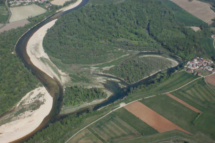
This paved the way for the recognition of a space of freedom [12] for watercourses. This area aims to satisfy users in the long term and ensure territorial development while protecting the river’s natural infrastructure. It is an operational tool for sustainable development. Understanding the functioning of certain watercourses has thus made it possible to rehabilitate lateral erosion, long considered a scourge to be fought. This erosion is now perceived as an opportunity, an ecological and landscape driver, guaranteeing environmental quality and territorial attractiveness (Figure 8).
The space of freedom has paved the way for the space of good functioning [13]. This new envelope is defined in the SDAGE Rhône-Méditerranée [14] of 2016-2021 It is truly a tool for planning human interventions (development, restoration, maintenance, preservation). It allows local stakeholders to adapt to the dynamic nature of the river and to benefit as much as possible from all the advantages provided by this natural infrastructure. This adaptation to the functioning of river systems resonates with the adaptation of human societies that is being discussed today to cope with the consequences of climate change.
The interruption of solid transport or the simplification of the bed bottom can alter this operation and have a direct impact on the ecological richness of the river. This operation is also very important for the natural filtration of water and thus makes it possible to ensure a certain self-purification with regard to nitrates of agricultural origin. If these changes are accompanied by bed sinking, the impact on the adjacent groundwater reservoir can also be significant. It is common that some municipalities, bordering sinking watercourses, have had to deepen their catchment wells in order to meet the demand for water. The increasing scarcity of water resources is also causing tensions between users (fishermen, irrigators, industrialists).
4. Geomorphology at the service of the Rhône and its residents
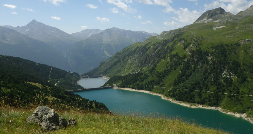
More and more scientific teams are organizing themselves to monitor the evolution of large rivers and answer sometimes complex questions. This is the case in Colorado, Mississippi but also in Europe, the Rhine, the Danube or the Rhône, on which a Rhône Sediment Observatory [15] was created 10 years ago.
There are many questions about the Rhône. They are of interest to users, local authorities along the river, the State, the Water Agency, and major operators, the CNR (Compagnie Nationale du Rhône) and EDF. Is it possible to supply the Camargue delta or even the Languedoc beaches, which are retreating under the influence of marine erosion, with fluvial sandy inputs? Do the dams built along its course fill with sediment? Does this have an impact on their management or on other parts of the river corridor? Is it possible to improve the ecological state of the river after a century of development to make it navigable and produce hydroelectricity? Is it possible to also improve its flow capacity by widening it to protect against flooding? Is there a risk of reintroducing into the river contaminants stored for a century in the sediments of its major bed? These are all questions on which researchers from the Observatoire des Sédiments du Rhône (OSR), geomorphologists, hydraulics, geochemists are currently working. The objective is to determine the evolutionary trajectory of the river, understand its functioning, evaluate its solid transport, simulate its evolution, and ultimately answer these questions.
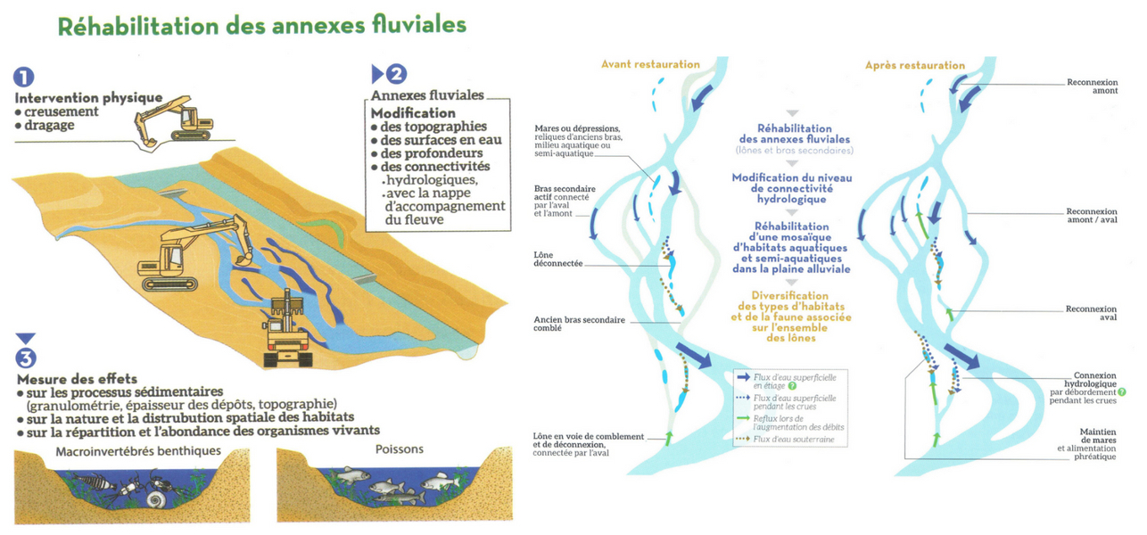
As part of the Rhône restoration plan initiated in the 1990s, remedial work has led to the reconnection of some secondary branches and the recreation of dead branches along the river in order to diversify habitats. Scientific monitoring of the restoration of the Rhône [18] (Figure 9) has thus made it possible to assess the lifespan of these arms, to demonstrate the sustainability of the actions undertaken and to confirm the diversity of the habitats created.
References and notes
Cover image. The Drôme in the Ramières reserve [© H.Piegay]
[1] http://www.reserves-naturelles.org/val-d-allier
[2] Leopold L.B., Wolman M.G., Miller, J.P. (1964). Fluvial processes in geomorphology. Courier Corporation.
[3] Schumm S.A. (1977). The fluvial system. J. Wiley.
[4] Amoros C., Petts G.E. (1993). River hydrosystems. Masson, Paris.
[5] http://www.eaufrance.fr/comprendre/la-politique-publique-de-l-eau/la-directive-cadre-sur-l-eau
[6] http://www.gesteau.fr/presentation/sdage
[7] Liébault F., Piégay H. (2002). Causes of 20th century channel narrowing in mountain and piedmont rivers of southeastern France. Earth surface processes and landforms 27, 425-444.
[8] Gaskin J.F., Schaal B.A., (2002). Hybrid Tamarix widespread in US invasion and undetected in native Asian range. Proceedings of the National Academy of Sciences 99, 11256-11259.
[9] https://fr.wikipedia.org/wiki/Risque_naturel
[10] https://fr.wikipedia.org/wiki/Al%C3%A9a_(natural_risk)
[11] https://www.legifrance.gouv.fr/affichTexteArticle.do;jsessionid=7C92280118C88D99523A184D3D96E6B0.tpdjo03v_3?idArticle=LEGIARTI000022746086&cidTexte=LEGITEXT000021263114&dateTexte=20131208
[12] http://sierm.eaurmc.fr/sdage/documents/guide-tech-2.pdf
[13] http://www.gesteau.fr/sites/default/files/guide-technique-sdage-rmc.pdf
[14] https://www.eaurmc.fr/le-bassin-rhone-mediterranee/le-sdage-du-bassin-rhone-mediterranee.html
[15] http://www.graie.org/osr/
[16] http://www.graie.org/zabr/index.htm
[17] http://ohm-vr.org/index.php
[18] https://restaurationrhone.univ-lyon1.fr/
The Encyclopedia of the Environment by the Association des Encyclopédies de l'Environnement et de l'Énergie (www.a3e.fr), contractually linked to the University of Grenoble Alpes and Grenoble INP, and sponsored by the French Academy of Sciences.
To cite this article: PIEGAY Hervé (January 5, 2025), Learning to live with rivers, a matter of geomorphology, Encyclopedia of the Environment, Accessed March 13, 2025 [online ISSN 2555-0950] url : https://www.encyclopedie-environnement.org/en/water/learning-live-with-rivers-a-matter-of-geomorphology-2/.
The articles in the Encyclopedia of the Environment are made available under the terms of the Creative Commons BY-NC-SA license, which authorizes reproduction subject to: citing the source, not making commercial use of them, sharing identical initial conditions, reproducing at each reuse or distribution the mention of this Creative Commons BY-NC-SA license.